
Des Plaines Postal ZIP Coverage
Official USPS material identifies four postal-city combinations for Des Plaines. They are routing tools, not municipal borders or resident lists. The accessible postal sources did not identify a current named station for each code, so the exact-address lookup remains the safe way to confirm delivery. The table preserves that gap rather than assigning unsupported neighborhoods or post offices.
| ZIP | Des Plaines Coverage | Post Office | Search Note |
|---|---|---|---|
| 60016 | Main postal-city set and much ordinary street delivery | Verify through USPS lookup | May include addresses beyond the incorporated city |
| 60017 | Des Plaines designation in official postal and county material | Current station and delivery class not verified | Treat as a postal key, not proof of a residential block |
| 60018 | Des Plaines plus Rosemont and O'Hare-area context | Verify through USPS lookup | Strong postal-city and municipal-boundary mismatch |
| 60019 | Smaller or specialized Des Plaines postal-city code | Current station and delivery class not verified | Do not assume broad household coverage |
The USPS postal bulletin is the source for the four-code set. USPS itself warns that a ZIP result does not confirm that a person or company is at an address. A Des Plaines ZIP code directory therefore needs a second geography source whenever city jurisdiction or parcel identity matters.
Des Plaines ZIP 60016
Use 60016 as a postal filter for an exact address, not as shorthand for every parcel inside Des Plaines. It is the main postal-city set and covers much of the ordinary street-delivery core, yet the research also shows that it can serve places beyond the incorporated line. A portal result should be checked against the city name, street, house number, and county PIN.
The Cook property information portal accepts ZIP as an optional address field. The Illinois voter lookup requires a five-digit ZIP before it loads the street choices. I-CASH can also narrow a name by city and ZIP. Each tool asks a different question: parcel and tax facts, a specific registration match, or an unclaimed-property clue. None produces a full list of 60016 residents.
Once a parcel or street is known, use the Des Plaines street directory for the address-level chain. The ZIP step should narrow the place, while the street number, PIN, and official record carry the identity work.
Des Plaines ZIPs 60017 and 60019
Official postal material includes 60017 and 60019, but the accessible consumer pages did not establish their current station names or full delivery classification. That missing detail matters. A code described elsewhere as administrative, specialized, or tied to boxes should not be presented as a broad residential zone without a current USPS address result.
Start with USPS ZIP Code Lookup. Search the exact street address, city, and state. If an older record supplies only the code, check Postmaster Finder or the USPS AIS Viewer for postal history and ZIP+4 context, then compare the address with CookViewer or city maps. Phone or in-person USPS contact is the fallback when the web tool cannot resolve a historic or specialized code.
Note: No current named post-office station or broad household coverage was verified for 60017 or 60019, so exact-address confirmation is essential.
Des Plaines ZIP 60018 Mismatch
ZIP 60018 supplies the clearest local lesson about postal geography. Official material connects it with Des Plaines and adjacent Rosemont or O'Hare-area addresses. A mailing label can say Des Plaines while the parcel sits in another municipal jurisdiction. The reverse can also happen when a city parcel carries a nearby postal label.
Municipal departments, wards, permits, and local code depend on the incorporated boundary, not the ZIP name. Deeds and taxes depend on the Cook County parcel and legal description. USPS controls delivery. Census ZIP Code Tabulation Areas provide statistical geography. Keep those four systems separate, especially near O'Hare, Rosemont, Mount Prospect, Elk Grove Village, Park Ridge, and Niles.
The successful manifest capture comes from the USPS Des Plaines ZIP information.
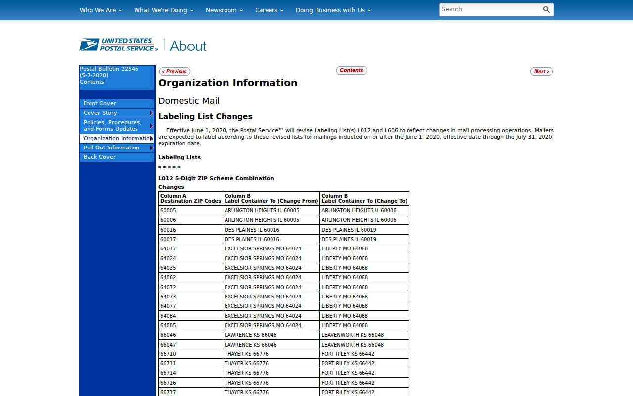
The bulletin supports the postal combinations. It does not draw the city boundary or prove who receives mail at an address.
Search Des Plaines by ZIP
A ZIP code directory is most useful as the first filter in a controlled search. Verify the code before entering it in a property or voter portal. Then capture the exact address and PIN. If the code and city line disagree, let the agency responsible for the fact decide: USPS for delivery, Des Plaines for city records, and Cook County for parcels.
- Run USPS ZIP by address using the street, city, and state. Save the exact five-digit result and ZIP+4 if shown.
- Enter house number, street, city, unit when needed, and optional ZIP in Cook County Property Information. A known PIN can bypass the address mode.
- Open CookViewer or the Des Plaines Community Portal to confirm parcel geometry and municipal context. Neither is a ZIP-wide household browser.
- Use the state voter lookup only when the name, birth date, ZIP, street number, and street selection are already known for a legitimate registration check.
- For older addresses, compare the postal result with library directories, county legal descriptions, city addressing rules, and historic place names.
A failed query may reflect a format issue rather than a wrong ZIP. Remove an unneeded direction or unit, confirm street spelling, and try the PIN route. If the address has changed, carry both the old and new number into the library, deed, and city-record search.
Des Plaines ZIP Property Fields
The Cook County Property Information portal is the main researched public record with a ZIP field. It can return tax bills, payments, exemptions, classification, tax-sale or appeal references, and related document links after an address or PIN search. ZIP is optional. That design is useful when a postal code is uncertain but the parcel number is known.
| Field | Type | Rule | ZIP Use |
|---|---|---|---|
| Search by PIN | Mode | Alternative to address | No ZIP required |
| House Number | Text | Required in address mode | Pairs with street and city |
| Street | Text | Required | Enter without unsupported assumptions |
| City | Text | Required | Use the portal's address label |
| Unit | Text | Optional | Narrows a multi-unit address |
| ZIP | Text | Optional or conditional | Portal validates the entered code |
The Assessor address search does not expose a ZIP field. It uses house number, direction, street name, city, and related controls, or a PIN and neighborhood path. CookViewer locates addresses, intersections, and parcels rather than offering a verified ZIP-wide filter. These differences explain why one portal can accept a code that another does not.
Des Plaines ZIP Address Logic
Des Plaines street numbers follow a local grid. North-south streets increase south from specified section lines, while east-west streets increase east. City code uses 800 numbers per mile and 100 numbers per one-eighth mile, with odd and even sides designated. Community Development assigns numbers and may correct a duplication, conflict, or other error.
This 800-per-mile pattern is a useful local quirk, but it cannot replace a postal lookup. An old address may use a former number, place name, or municipal context. Orchard Place, formerly Farwell, was annexed in 1956. Earlier land and directory searches may use Maine Township, Rand, Orchard Place, or another label instead of modern Des Plaines.
When an address fails, compare three layers. First, ask USPS for the current postal city and ZIP. Second, use the city code, maps, and old directory evidence for the street name or number. Third, use Cook County PIN lineage, lot and block, subdivision, tract, and legal description. Only then should a gap be treated as a missing record.
Des Plaines ZIPs and ZCTAs
Census data identifies ZCTAs 60007, 60016, 60018, 60056, and 60068 as fully or partly within the Des Plaines profile context. A ZCTA, or ZIP Code Tabulation Area, is a Census statistical shape. It approximates patterns formed by postal routes but is not a USPS delivery code or city boundary.
Use Census data for population and demographic analysis, not to validate mail or assign a parcel to the city. A ZCTA can overlap Mount Prospect, Rosemont, Elk Grove Village, Park Ridge, Niles, and other places. Counts drawn from it should be labeled with the statistical geography used.
That distinction prevents a common error: treating a count for 60018 as the count of people inside Des Plaines city limits. The postal code, ZCTA, parcel map, and incorporated city can all draw different shapes over the same area.
Des Plaines ZIP and City Limits
For a record request, identify the keeper from the boundary that governs the record. Des Plaines City Clerk handles city maps, ward material, and municipal records through counter, phone, and written FOIA channels. Cook County maintains parcel, tax, deed, and election sources. USPS handles delivery and postal history. DPPL and the History Center help bridge older directories, phone books, street names, and place labels.
No ZIP code can answer who lives at an address, whether someone receives mail there, or where a former resident moved. It can narrow a search. Current identity still requires the record that directly answers the question, with privacy and access rules observed.
- ZIP and ZIP+4
- A ZIP is the five-digit delivery area. ZIP+4 narrows the route, block, building, or delivery segment.
- PO-box ZIP
- A code used mainly or only for post-office boxes rather than ordinary street delivery.
- Unique ZIP
- A code assigned to one organization or a very high-volume recipient. None was verified for a specific Des Plaines institution.
- Carrier route
- The group of delivery points served by one postal route, which is more precise than the five-digit code.
- Situs address
- The property's location label in county records, which may differ from a tax-mailing or USPS address.
Boundary rule. Use USPS for mail, city maps for municipal limits, CookViewer and the PIN for parcels, and Census ZCTAs only for statistics.